LU aerial drone surveys Hurricane Laura’s damage to coastal protection
September 14, 2020 | by Shelly Vitanza
Lamar University’s Department of Earth and Space Sciences utilized an aerial drone this week to take photos and video imagery of Jefferson County’s coastline’s status in the aftermath of Hurricane Laura.
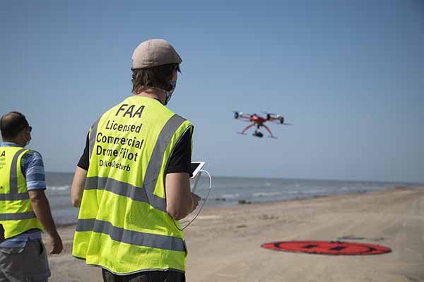
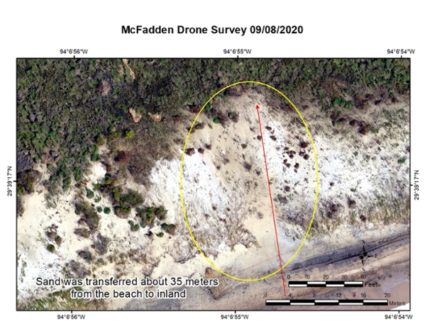
Using a thermal-infrared camera visible light images depict removed vegetation and generate a 3-D surface digital model to determine the areas Hurricane Laura impacted and identify the areas that need immediate restoration.
“The thermal infrared images are used to determine where sand was washed out and transferred from beach to inland by storm surge,” said Dr. Reda Amer, assistant professor and director of Lamar Geospatial Center and director of GIS programs in LU’s Department of Earth & Space Sciences and principal investigator for this project. “The next step is to integrate the very high-resolution LiDAR system with the very high-resolution images to generate GIS models to measure the erosion rates and the effectiveness of the clay/sand berm to reduce the erosion in Jefferson County's coastal land.”
The rebuilding of the Jefferson County beach and dune system has been a top priority for state and federal natural resource agencies and Jefferson County for decades, especially after Hurricane Ike’s 2008 negative impact on the beach.
The Texas Point Sabine Pass buoy operated by the National Weather Service had registered two “major flooding” occurrences in Jefferson County as Hurricane Laura was making landfall in Cameron Parish, LA at high tide prior to and right after midnight of August 26-27.
The NWS buoy showed a slightly more than 4-foot storm surge close to midnight on Aug. 26 followed by a second, larger major flooding event of 4.72 feet around 1 a.m. on Aug. 27, according to a buoy reading provided by the National Weather Service.
“As LU faculty in the environmental sciences, we have a responsibility to contribute our talents for the good of all the public and private stakeholders and resource managers in our community,” said Dr. Matthew Hoch, associate professor of biology and aquatic and microbial ecology. “Teaming with experts in the LU Geospatial Center to also contribute to monitoring beach berm and dune was a vision which is coming to fruition with a little nudge from Laura.”
Texas’ largest contiguous coastal marsh is located behind 20 miles of beach front in Jefferson County and parts of Chambers County. The coastal marsh totals approximately 140,000 acres and includes the McFaddin National Wildlife Refuge, managed by the U.S. Fish and Wildlife Service, and the J.D. Murphree Wildlife Management Area, managed by the Texas Parks and Wildlife Department. Full beach and dune restoration is a significant priority of Texas and federal agencies, including allocations of Texas’ share of Deepwater Horizon restoration funding.
Maintaining the desired mix of fresh and saltwater within the marsh is an ongoing management goal of natural resource agencies to conserve optimum vegetation health, which in turn provides habitat for migratory birds, waterfowl, alligators and insects as well as critically important nursery areas for finfish and shellfish.
Significant public recreation amenities including fishing, birding and waterfowl hunting depend upon a healthy marsh ecosystem.
"The goal of restoring our coastal marsh ecosystem has been a unifying cause for Texas and Washington natural resource leaders," said Jefferson County Judge Jeff R. Branick. "A broad base of local stakeholders, including NGOs, local governments and industry is vital. One of the things we've learned over the years is that planning precedes funding, and Lamar University's data gathering, such as the drone overflight of Hurricane Laura impacts, plus their leadership in convening regional flood control strategy meetings is forging needed consensus on next steps."
The Texas General Land Office oversaw a three-mile beach and dune restoration pilot project in 2017 along Jefferson County’s 20 miles of coast. Preliminary damage assessment after Hurricane Laura, including today’s drone imagery, indicates that the beach and dune pilot project held up well, as it was designed to do.
 In addition, a 20-mile-long, four-to-five-foot high clay berm set back more than 200 meters behind the beach did experience pressure from Hurricane Laura’s storm surge, including overtopping and some breached areas. However, a full estimate of the coastline’s status is forthcoming in an engineering report. Vegetative debris was documented up against and on top of some of the clay berm. The clay berm experienced the most breached areas where there was no prior dune repair and held up best behind the three-mile pilot project.
The U.S. Fish and Wildlife Service, Texas Parks and Wildlife Department, Jefferson County, Jefferson County Drainage District 6, Texas Commission for Environmental Quality and Ducks Unlimited participate in the Salt Bayou Watershed Restoration Working Group along with the National Marine Fisheries Service of the National Oceanic and Atmospheric Administration, the U.S. Army Corps of Engineers and the Texas Water Development Board.
Marsh health is a vital means to reduce tropical storm and hurricane storm surge that can threaten lives, homes, industry, ports and national defense assets in Jefferson County including Port Arthur and Beaumont.
“The Chenier Plain marsh complex which includes Salt Bayou Watershed is a state and nationally treasured resource, which so many in our SETX communities enjoy personally and benefit from in less obvious ways, such as coastal community infrastructure protection,” Hoch said. “Restoration efforts to return to an ecologically and functionally resilient beach front are critical to dune ecosystem wildlife and the inshore marshes.”
The Federal Emergency Management Agency has reported that Jefferson County contains a rich collection of more Deepwater Horizon impacted wildlife and coastal resources than are typically found along the Gulf of Mexico coast.
Aerial data products taken and interpreted by Dr. Reda Amer, assistant professor and director of Lamar Geospatial Center and director of GIS programs in LU’s Department of Earth & Space Sciences and principal investigator for this project.